یورکشر
بخشی تاریخی در شمال انگلند
(تغییرمسیر از یورکشر)
یورکشایر (انگلیسی: Yorkshire;/ˈjɔːkʃə/) یک شهر در شمال انگلستان و بزرگترین در بریتانیا است.[۳] این شهرستان به بخشهای یورکشر شمالی، یورکشر جنوبی، یورکشر غربی و ایست رادینگ آو یورکشر تقسیم میشود.
| یورکشایر | |
|---|---|
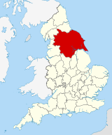
 Yorkshire within England, showing historic extent | |
| مساحت | |
| • ۱۸۳۱ | ۳٬۶۶۹٬۵۱۰ جریب فرنگی (۱۴٬۸۵۰ کیلومتر مربع)[۱] |
| • ۱۹۰۱ | ۳٬۸۸۳٬۹۷۹ جریب فرنگی (۱۵٬۷۱۸ کیلومتر مربع)[۱] |
| • ۱۹۹۱ | ۲٬۹۴۱٬۲۴۷ جریب فرنگی (۱۱٬۹۰۳ کیلومتر مربع)[۱] |
| جمعیت | |
| • ۱۸۳۱ | 1,371,359[۱] |
| • ۱۹۰۱ | 3,512,838[۱] |
| • ۱۹۹۱ | 3,978,484[۱] |
| • ۲۰۱۱ | 5,288,200[۲] |
| تراکم | |
| • ۱۸۳۱ | ۰٫۳۷ ساکن در هر جریب (۹۱ ساکن در هر کیلومتر مربع) |
| • ۱۹۰۱ | ۰٫۹ ساکن در هر جریب (۲۲۰ ساکن در هر کیلومتر مربع) |
| • ۱۹۹۱ | ۱٫۳۵ ساکن در هر جریب (۳۳۰ ساکن در هر کیلومتر مربع) |
| تاریخچه | |
| • Origin | Kingdom of Jórvík |
| ساخت | In antiquity |
| جایگزین | Various |
| Chapman code | YKS |
| Subdivisions | |
| • Type | Ridings |
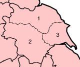
| • Units | 1 North • 2 West • ایست رادینگ آو یورکشر |
 | |
منابع
ویرایش- ↑ ۱٫۰ ۱٫۱ ۱٫۲ ۱٫۳ ۱٫۴ ۱٫۵ "200 years of the Census in Yorkshire" (PDF). National Statistics. 2001. Retrieved 15 July 2008. Note that the area of Yorkshire increases slightly from ۳٬۶۶۹٬۵۱۰ جریب فرنگی (۱۴٬۸۵۰ کیلومتر مربع) in 1831 to ۳٬۸۸۳٬۹۷۹ جریب فرنگی (۱۵٬۷۱۸ کیلومتر مربع) in 1901 and then reduces to ۲٬۹۴۱٬۲۴۶ جریب فرنگی (۱۱٬۹۰۳ کیلومتر مربع) in 1991, so that these three figures relate to different areas.
- ↑ "Table 8a Mid-2011 Population Estimates: Selected age groups for local authorities in England and Wales; estimated resident population;". Population Estimates for England and Wales, Mid 2011 (Census Based). Office for National Statistics. 2012-09-25. Retrieved 2012-11-22.
- ↑ G. Gibbons, Yorkshire: Britain's Largest County (London: Geographica Ltd. , 1969).
- Wikipedia contributors, "Yorkshire," Wikipedia, The Free Encyclopedia, http://en.wiki.x.io/w/index.php?title=Yorkshire&oldid=548790990 (accessed April ۱۵، ۲۰۱۳).
پیوند به بیرون
ویرایشدر ویکیانبار پروندههایی دربارهٔ یورکشر موجود است.