پرونده:East-Hem 565ad.jpg

پروندهٔ اصلی (۳٬۲۴۰ × ۱٬۹۰۳ پیکسل، اندازهٔ پرونده: ۷۷۳ کیلوبایت، نوع MIME پرونده: image/jpeg)
این پرونده در ویکیانبار موجود است. محتویات صفحهٔ توصیف آن در زیر نمایش داده میشود. |

|
این historical map نگاره میبایست با استفاده از گرافیک برداری اسویجی فایل بازسازی شوند. این چند مزیت دارد؛ Commons:Media for cleanup را برای اطلاعات بیشتر ببینید. اگر حالت برداری آن در حال حاضر موجود است، لطفاً آن را بار کنید. پس از بارکردن یک اسویجی، این الگو را با {{vector version available|new image name.svg}} جایگزین کنید.
|


| توضیح |
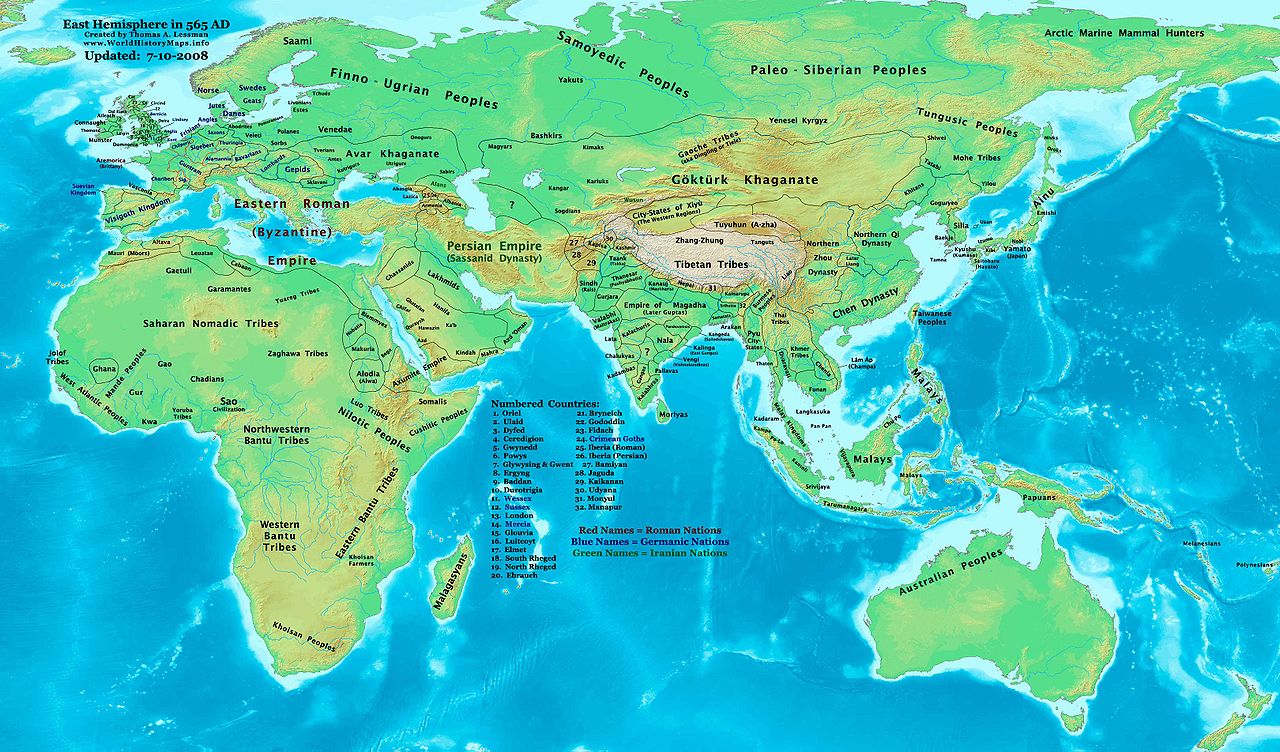
English: Eastern Hemisphere in 565 AD |
| منبع | self-made (For reference information, see the Map Source References section below.) |
| پدیدآور | Thomas Lessman (Contact!) |
| اجازهنامه (استفادهٔ مجدد از این پرونده) |
من، صاحب حقوق قانونی این اثر، به این وسیله این اثر را تحث اجازهنامهٔ ذیل منتشر میکنم: این پرونده با اجازهنامهٔ کریتیو کامانز Attribution-Share Alike 3.0 سازگار نشده منتشر شده است.
|
| دیگر نسخهها |
آثار انشقاقی از این پرونده: see East-Hem_565ad.jpg file history on Wikipedia. |
Map Summary
Original Source URL: http://www.thomaslessman.com/History/images/East-Hem_565ad.jpg.
This map of the Eastern Hemisphere in 565 AD was created by Thomas Lessman, based on information from the sources listed below. This map is free for educational use (see Permission info above). When using this map, please mention that it is available for free at www.WorldHistoryMaps.info.
Map Source References
- Remember, sources often conflict with each other. This map is only as accurate as the information that is available to me. To report any errors or to help further this work, please click here, or email Thomas Lessman at talessman@yis.us
References for information contained in this map:
Primary Sources for East-Hem_565ad.jpg:
- 1. The DK Atlas of World History, 2000 Edition; map of The World in 500 CE, (Pages 50-51) (See other specific references below)
- 2. John Nelson. Map of the "Countries of the World 1/1/565 CE." Interactive Historical Atlas of the World since 500BCE. World History Maps Inc., Alexandria, VA, 2008. Available at www.WorldHistoryMaps.com.
- 3. The History & Commercial Atlas of China, maps of The Divisions of China, 530 & 560 AD and Asia in 610 AD, available at Huhai.net
- 4. Wikimedia's World Map 500 CE, made by User:Javierfv1212, and Wikipedia articles (noted below).
I - African Information
Note: Most of my African Information comes from The DK Atlas of World History map of The Development of Complex Societies in Africa; (Pg 160).
- (Bantus, Berber Tribes, Chadians, Cushites, Daamat, Garamantes, Gur, Khoisan Peoples, Kwa, Libyans, Mandes, Nilotic Peoples, West Atlantic Peoples)
- Nubian/Sudanese borders (Makuria, Nobatia, Alodia, Blemmyes, Bega, Axum, etc.) are derived from these sources:
- 1. The DK Atlas of World History map of "Northeast Africa, c. 500 CE"; (Pg. 161)
- 2. Denis Bellemare. Historical Atlas of Late Antiquity. Map of Arabia in 540 AD
- Ghana's location is derived from John Nelson's map of the "Countries of the World, 1-1-500 CE", available at www.WorldHistoryMaps.com.
- North African borders are derived from a comparison of
- 1. Denis Bellemare. Historical Atlas of Late Antiquity. Comparison of the maps of North Africa in 540 AD and North Africa in 580 AD.
II - Asian Information
- Arabian borders & Tribal locations are derived from a combination of these sources:
- 1. The MidEastWeb.org map of Arabia in 500 CE.
- 2. Denis Bellemare. Historical Atlas of Late Antiquity. Maps of "Southern Arabia in 540 AD and North Arabia in 540 AD.
- 3. Wikipedia's map of Pre-Islamic Arab tribal locations, created by User:Slackerlawstudent.
Note: I used information in various Wikipedia articles to reconcile the maps and the borders I depict for Arabia.
- Chinese Borders are derived from the History & Commercial Atlas of China, map of The Divisions of China, 530 & 560 AD, available on Huhai.net
- India's borders are derived from these sources:
- 1. John Nelson. Map of the "Countries of the World 1/1/565 CE." Interactive Historical Atlas of the World since 500BCE. World History Maps Inc., Alexandria, VA, 2008. Available at www.WorldHistoryMaps.com.
- 2. The Historical Atlas of South Asia, maps of "The Gupta-Vakataka Age, c. A.D. 300-500" and "The age of Pusyabhuti and Calukyan ascendancy, c. A.D. 550-700", by Joseph Schwartzberg.
- Japanese information is derived from The DK Atlas of World History map of "State Formation in Korea & Japan to 650 CE"; (Pg 264)
III - European Information
Note: Borders of Europe are mostly derived from a combination of:
1. The www.Euratlas.com map of Europe in 600 AD and to a lesser extent, their map of Europe in 500 AD.
- (Please note: User:Bogomolov.PL has done a great job of showing me possible discrepancies in my north European borders compared to this source, due to the differences in the geographical layout of the maps.)
2. John Nelson. Map of the "Countries of the World 1/1/565 CE." Interactive Historical Atlas of the World since 500BCE. World History Maps Inc., Alexandria, VA, 2008. Available at www.WorldHistoryMaps.com.
- British/English Borders derived from "Early British Kingdoms" map of Britain in 550 AD and their map of Britain in 575 AD.
4. Fringe areas like Africa, Australia, Siberia, etc. are partially derived from Wikimedia's map of The world in 500 CE, created by User:Javierfv1212.
5. Much of the information in this map was cross-checked with Bruce Gordon's Regnal Chronologies.
Other Maps by Thomas Lessman
| Maps of the eastern hemisphere showing history
Bold dates are available on Wikimedia or Wikipedia. | ||
| Primeval | ||
| Ancient
|
·| 600 BC | 550 BC | 527 BC | 500 BC |
400 BC | ·| 1 AD | 50 AD | 100 AD | 200 AD | 300 AD | | |
| Medieval |
·| 500 AD | 565 AD | 600 AD | 700 AD | | |
| Modern |
·| 1500 AD | · * For historical maps of the whole world, | |
تاریخچهٔ پرونده
روی تاریخ/زمانها کلیک کنید تا نسخهٔ مربوط به آن هنگام را ببینید.
| تاریخ/زمان | بندانگشتی | ابعاد | کاربر | توضیح | |
|---|---|---|---|---|---|
| کنونی | ۱۰ ژوئیهٔ ۲۰۰۸، ساعت ۲۲:۲۹ | | ۳٬۲۴۰ در ۱٬۹۰۳ (۷۷۳ کیلوبایت) | Talessman | |
| ۹ مهٔ ۲۰۰۸، ساعت ۲۱:۱۸ |  | ۳٬۲۴۰ در ۱٬۹۰۳ (۷۶۰ کیلوبایت) | Talessman | {{Information |Description=Eastern Hemisphere in 565 AD. |Source=self-made |Author=Thomas Lessman |Permission={{self|cc-by-sa-3.0}} }} |
کاربرد پرونده
صفحههای زیر از این تصویر استفاده میکنند:
کاربرد سراسری پرونده
ویکیهای دیگر زیر از این پرونده استفاده میکنند:
- کاربرد در azb.wiki.x.io
- کاربرد در be.wiki.x.io
- کاربرد در br.wiki.x.io
- کاربرد در de.wiki.x.io
- کاربرد در el.wiki.x.io
- کاربرد در en.wiki.x.io
- کاربرد در es.wiki.x.io
- کاربرد در fr.wiki.x.io
- کاربرد در hr.wiki.x.io
- کاربرد در hy.wiki.x.io
- کاربرد در ka.wiki.x.io
- کاربرد در mn.wiki.x.io
- کاربرد در no.wiki.x.io
- کاربرد در pt.wiki.x.io
- کاربرد در rue.wiki.x.io
- کاربرد در ru.wiki.x.io
- کاربرد در sh.wiki.x.io
- کاربرد در sl.wiki.x.io
- کاربرد در sv.wiki.x.io
- کاربرد در tr.wiki.x.io
- کاربرد در uk.wiki.x.io
- کاربرد در vi.wiki.x.io