پرونده:East-Hem 300ad.jpg

پروندهٔ اصلی (۳٬۲۴۰ × ۱٬۹۰۳ پیکسل، اندازهٔ پرونده: ۷۳۹ کیلوبایت، نوع MIME پرونده: image/jpeg)
این پرونده در ویکیانبار موجود است. محتویات صفحهٔ توصیف آن در زیر نمایش داده میشود. |

|
این historical map نگاره میبایست با استفاده از گرافیک برداری اسویجی فایل بازسازی شوند. این چند مزیت دارد؛ Commons:Media for cleanup را برای اطلاعات بیشتر ببینید. اگر حالت برداری آن در حال حاضر موجود است، لطفاً آن را بار کنید. پس از بارکردن یک اسویجی، این الگو را با {{vector version available|new image name.svg}} جایگزین کنید.
|


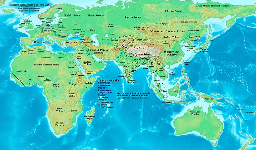
| توضیح | Eastern Hemisphere in 300 AD. |
| منبع | self-made (For reference information, see the Map Source References section below.) |
| پدیدآور | Thomas Lessman (Contact!) |
| اجازهنامه (استفادهٔ مجدد از این پرونده) |
من، صاحب حقوق قانونی این اثر، به این وسیله این اثر را تحث اجازهنامهٔ ذیل منتشر میکنم: این پرونده با اجازهنامهٔ کریتیو کامانز Attribution-Share Alike 3.0 سازگار نشده منتشر شده است.
|
| دیگر نسخهها | see East-Hem_300ad.jpg file history on Wikipedia. |
.jpg)
Map Summary
Original Source URL: http://www.thomaslessman.com/History/images/East-Hem_300ad.jpg.
This map of the Eastern Hemisphere in 300 AD was created by Thomas Lessman, based on information from the sources listed below. This map is free for educational use (see Permission info above). When using this map, please mention that it is available for free at www.WorldHistoryMaps.info.
Map Source References
- Remember, sources often conflict with each other. This map is only as accurate as the information that is available to me. To report any errors or to help further this work, please click here, or email Thomas Lessman at talessman@yis.us
References for information contained in this map:
Primary Sources
- 1. The DK Atlas of World History, 2000 Edition; map of The World in 250 CE; (Pg 46-47)
- 2. Wikimedia's map of the World in 300 AD, made by User:Javierfv1212.
- 3. WorldHistoryMaps.com's maps of the World in 275 CE and the World in 340 CE.
I - European Information is derived primarily from this map of Europe in 300 AD, available on www.Euratlas.com.
II - Asian Information is derived primarily from these sources:
- Caucasian borders come from the Euratlas.com map of Europe in 300 AD.
- (Albania, Armenia, Colchis, Iberia, and Lazica)
- Funan borders are derived from:
- 1. The DK Atlas of World History, 2000 Edition; map of The World in 250 CE, (Pg 46-47).
- 2. Wikipedia's article about Funan, along with this map of Funan in 001, uploaded by User:L_joo.
- Indian information is derived from these sources:
- 1. This map of the Expansion of the Guptas[dead link] from Mapas Imperiales archive copy at the Wayback Machine.
- Note: I do not know what source was used for info in this "Expansion of the Guptas" map, nor whom the original author is. The map covers the years after 300 AD, but shows the placement of kingdoms which were conquered by the rising Gupta. Thus they would most likely have been in existance in 300 AD. Some of these kingdoms can be verified thru their Wikipedia articles, others have little or no info currently available.
- (Dvaka, Guptas, Kamarupa, Licchavis, Nagas, Pundravardhana, Samatata, Vakatakas, Western Satraps).
- 2. WorldHistoryMaps.com's map, "Countries of the World, 1-1-275 CE".
- (Abhiras, Ahicchatra, Andhra Ikshvakus, Ay, Cheras, Cholas, Kadambas, Kongu, Nagas, Pallavas, Pandyas, Vakatakas, Yaudheya)
- 3. Wikimedia's map of the World in 300 AD and Wikipedia articles for:
- (Sassanids, Western Satraps, etc.)
- Korean borders derive primarily from this map of the History_or_Korea-315.png made by Wikipedia's User:Historiographer.
- Note: borders for Daifang Commandery are based on User:Historiographer's map of the History_of_Korea-204.png.
- Kushanshah and East Kushans information comes from:
- 1. Wikipedia's article on the Kushan Empire, which states the Kushan Empire split into 2 kingdoms after 225; the western kingdom (in Afghanistan) fell to the Sassanid Persians by 240 AD and became known as Kushanshas, and the eastern kingdom (in India) fell to the Guptas in the late 4th or early 5th century.
- 2. WorldHistoryMaps.com's map of the "Countries of the World, 1-1-275 CE", which shows borders of a kingdom called "Takasila", which corresponds to the Kushansha holdings.
- Lakhmid borders are based on information from Wikipedia's article about the Lakhmids
- Note: The article notes that King Imru' al-Qais I ibn 'Amr (R. 288-328 AD) expanded Lakhmid power along the coast to Bahrain, but was defeated around 321 by the Sassanids.
- Lâm Áp/Linyi information comes from Wikipedia's article about the Champa states, which were dominated by Lâm Áp from 192-756 AD).
- Malay kingdoms are described mostly in their Wikipedia articles, including:
- Kantoli, Kedah, Langkasuka (and this Map of Langkasuka), Pan Pan (and this Map of Pan Pan),
- Pyu city-states are derived from Wikipedia's article about the Pyu city-states and Wikimedia's map of the World in 300 AD.
- Sassanid Persian Empire borders are derived from:
- 1. Eastern Sassanid borders are based on the map of The World in 250 CE on (Pg 46-47) of The DK Atlas of World History, 2000 Edition.
- 2. Western Sassanid borders are based on the Euratlas.com map of Europe in 300 AD.
- Srivijaya borders are derived from Wikimedia's map of the World_in_300_CE.PNG (see above, #2 under Primary Sources) and the Wikipedia article about Srivijaya.
- Tarim Basin Kingdoms (Kashgar, Hotan, Kuqa, Karaxahr, Turfan, and Shanshan) derive from the Tarim Basin article on Wikipedia, along with Wikimedia's map of Tarim Basin, 3rd Century CE, created by User:Schreiber.
- Western Jin Dynasty borders are derived from the History and Commercial Atlas of China map of the Western Tsin Dynasty (265-316 AD), available on Huhai.net.
- Yueban/Xiongnu are described in the Wikipedia article about Yueban.
III - African Information and information for fringe areas like Australia, Siberia, etc. derive from:
- 1. The DK Atlas of World History, 2000 Edition; map of The development of complex societies in Africa; (Page 160).
- 2. Wikimedia's map of the World in 300 AD, made by User:Javierfv1212.
- 3. The map of Europe in 300 AD, available on www.Euratlas.com (used for Roman borders in North Africa).
Note: Much of the information in this map was cross-checked with Bruce Gordon's Regnal Chronologies.
Other Maps by Thomas Lessman
| Maps of the eastern hemisphere showing history
Bold dates are available on Wikimedia or Wikipedia. | ||
| Primeval | ||
| Ancient
|
·| 600 BC | 550 BC | 527 BC | 500 BC |
400 BC | ·| 1 AD | 50 AD | 100 AD | 200 AD | 300 AD | | |
| Medieval |
·| 500 AD | 565 AD | 600 AD | 700 AD | | |
| Modern |
·| 1500 AD | · * For historical maps of the whole world, | |
تاریخچهٔ پرونده
روی تاریخ/زمانها کلیک کنید تا نسخهٔ مربوط به آن هنگام را ببینید.
| تاریخ/زمان | بندانگشتی | ابعاد | کاربر | توضیح | |
|---|---|---|---|---|---|
| کنونی | ۲۸ مهٔ ۲۰۰۸، ساعت ۰۵:۰۸ | | ۳٬۲۴۰ در ۱٬۹۰۳ (۷۳۹ کیلوبایت) | Talessman | Major corrections to borders in India and central Asia, corrections to Western Jin and SE Asian borders, added more info for Asia and Africa, other changes. |
| ۲۶ مهٔ ۲۰۰۸، ساعت ۱۸:۴۷ |  | ۳٬۲۴۰ در ۱٬۹۰۳ (۷۲۴ کیلوبایت) | Talessman | Version 2 (12-25-08). Minor border changes and added more information. | |
| ۱۶ دسامبر ۲۰۰۷، ساعت ۲۰:۰۸ |  | ۳٬۲۴۰ در ۱٬۹۰۳ (۶۷۱ کیلوبایت) | Mhaesen | == Summary == Author: Thomas A. Lessman. Source URL: http://www.ThomasLessman.com/History/images/East-Hem_300ad.jpg. Image was created by Thomas Lessman based on historical information located in sources listed below. This map is free for public and/or ed |
کاربرد پرونده
صفحههای زیر از این تصویر استفاده میکنند:
کاربرد سراسری پرونده
ویکیهای دیگر زیر از این پرونده استفاده میکنند:
- کاربرد در arz.wiki.x.io
- کاربرد در as.wiki.x.io
- کاربرد در azb.wiki.x.io
- کاربرد در bn.wiki.x.io
- کاربرد در bs.wiki.x.io
- کاربرد در ckb.wiki.x.io
- کاربرد در el.wiki.x.io
- کاربرد در en.wiki.x.io
- کاربرد در es.wiki.x.io
- کاربرد در frr.wiki.x.io
- کاربرد در fr.wiki.x.io
- کاربرد در gl.wiki.x.io
- کاربرد در he.wiki.x.io
- کاربرد در incubator.wikimedia.org
- کاربرد در jv.wiki.x.io
- کاربرد در km.wiki.x.io
- کاربرد در lv.wiki.x.io
- کاربرد در mk.wiki.x.io
- کاربرد در my.wiki.x.io
- کاربرد در ne.wiki.x.io
- کاربرد در nl.wiki.x.io
- کاربرد در nn.wiki.x.io
- کاربرد در pl.wiki.x.io
- کاربرد در ro.wiki.x.io
- کاربرد در rue.wiki.x.io
- کاربرد در ru.wiki.x.io
- کاربرد در shn.wiki.x.io
- کاربرد در sh.wiki.x.io
- کاربرد در sv.wiki.x.io
- کاربرد در sw.wiki.x.io
- کاربرد در ta.wiki.x.io
نمایش استفادههای سراسری از این پرونده.