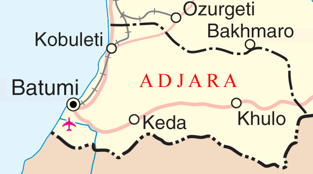
پرونده:Adjara map.png
Adjara_map.png (۶۳۴ × ۳۵۴ پیکسل، اندازهٔ پرونده: ۴۵ کیلوبایت، نوع MIME پرونده: image/png)
تاریخچهٔ پرونده
روی تاریخ/زمانها کلیک کنید تا نسخهٔ مربوط به آن هنگام را ببینید.
| تاریخ/زمان | بندانگشتی | ابعاد | کاربر | توضیح | |
|---|---|---|---|---|---|
| کنونی | ۱۹ دسامبر ۲۰۰۶، ساعت ۲۲:۵۰ |  | ۶۳۴ در ۳۵۴ (۴۵ کیلوبایت) | Electionworld | {{ew|en|Osgoodelawyer}} Ajaria and surrounding area Map adapted from http://www.un.org/Depts/Cartographic/map/profile/georgia.pdf {{UN map}} Category:Maps of Georgia (country) |
کاربرد پرونده
صفحههای زیر از این تصویر استفاده میکنند:
کاربرد سراسری پرونده
ویکیهای دیگر زیر از این پرونده استفاده میکنند:
- کاربرد در af.wiki.x.io
- کاربرد در az.wiki.x.io
- کاربرد در ba.wiki.x.io
- کاربرد در be.wiki.x.io
- کاربرد در de.wiki.x.io
- کاربرد در frr.wiki.x.io
- کاربرد در fy.wiki.x.io
- کاربرد در hu.wiki.x.io
- کاربرد در incubator.wikimedia.org
- کاربرد در it.wiki.x.io
- کاربرد در ko.wiki.x.io
- کاربرد در ku.wiki.x.io
- کاربرد در ml.wiki.x.io
- کاربرد در pam.wiki.x.io
- کاربرد در pl.wiki.x.io
- کاربرد در pl.wiktionary.org
- کاربرد در pt.wiki.x.io
- کاربرد در ru.wiki.x.io
- کاربرد در rw.wiki.x.io
- کاربرد در sco.wiki.x.io
- کاربرد در sl.wiki.x.io
- کاربرد در su.wiki.x.io
- کاربرد در tr.wiki.x.io
- کاربرد در uk.wiki.x.io
- کاربرد در ur.wiki.x.io
- کاربرد در vi.wiki.x.io
- کاربرد در yo.wiki.x.io


