الگو:Infobox Belgium Municipality
این الگو یک الگوی سفارشی بستهبندیکنندهٔ {{جعبه اطلاعات منطقه مسکونی}} است و از همین روی در رده:الگو:فراخوانی جعبه اطلاعات منطقه مسکونی گنجانده شده است. هر پارامتری از {{جعبه اطلاعات منطقه مسکونی}} که پیشتر در این الگو نیز تعریف شده باشد، هنگام استفاده از این الگو کار خواهد کرد. این الگو همچنین میکروفرمتهای hCard و ژئو مشابه {{جعبه اطلاعات منطقه مسکونی}} را تولید خواهد کرد. پرسشی دارید؟ لطفاً آن را در بحث الگو:جعبه اطلاعات منطقه مسکونی مطرح کنید. |
This is a template to display the characteristics of a Belgian Municipality.
Usage
{{Infobox Belgium Municipality
|name=
|native_name=
|native_name_lang=
|namefr=
|namenl=
|namede=
|picture=
|picture-legend=
|map=
|arms=
|flag=
|map_dot_label=
|coordinates = {{Coord}}
|nis=
|arrondissement=
|list_of_mayors=
|mayor=
|majority=
|population_demonym=
| population_metro=
|postal-codes=
|telephone-area=
|web=
|footnotes=
}}
- nis = number identifying each Belgian municipality in Directorate-general Statistics Belgium [۱]; This number is used to retrieve data (population statistics, coordinates, economy data) from three subtemplates.
- for region, community and province you can use templates (see below), and else they are displayed based on the given NIS number
- the coordinates (lat_deg etc.) are needed for the dot on the map of Belgium and the title coordinates.
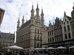
Example: Leuven
Leuven | |
|---|---|
| نویسهگردانی(های) Name | |
| • French | Louvain |
 Leuven Town Hall | |
| کشور | بلژیک |
| منطقه | منطقه فلمیش |
| Community | Flemish Community |
| استان | برابانت فلاندر |
| ناحیه | ناحیه اداری لوان |
| حکومت | |
| • شهردار | Louis Tobback (SP.A) |
| • Governing party/ies | SP.A-روح, CD&V-N-VA |
| مساحت | |
| • کل | ۵۶٫۶۳ کیلومتر مربع (۲۱٫۸۶ مایل مربع) |
| جمعیت (1 January 2016)[۱] | |
| • کل | ۹۹٬۲۸۸ |
| • تراکم | ۱۸۰۰/کیلومتر مربع (۴۵۰۰/مایل مربع) |
| کد پستی | 3000, 3001, 3010, 3012, 3018 |
| پیششماره | 016 |
| وبگاه | www.leuven.be |
{{Infobox Belgium Municipality
|name = Leuven
|namefr = Louvain
|picture = Leuven.jpg
|picture-legend = Leuven Town Hall
|map = LeuvenLocatie.png
|map-legend = Location of Leuven in Flemish Brabant
|arms = Wapen van Leuven.svg
|flag = Flag of Leuven.svg
|arrondissement = [[ناحیه اداری لوان]]
|nis = 24062
|mayor = [[Louis Tobback]] ([[SP.A]])
|majority = [[SP.A]]-[[روح]], [[CD&V]]-[[N-VA]]
|postal-codes = 3000, 3001, 3010, 3012, 3018
|telephone-area = 016
|web = [http://www.leuven.be/ www.leuven.be]
|coordinates = {{Coord|50|53|N|4|42|E}}
}}
منابع
- ↑ Population per municipality as of 1 January 2016 (XLS; 397 KB)
Useful templates
- Regions :
-
 بروکسل {{BE-BRU}}
 منطقه فلاندری use {{BE-VLG}}
 منطقه فلاندری {{BE-WAL}}
- Communities :
-
 Flemish Community {{BE-NL}}
 بخش فرانسوی {{BE-FR}}
 German-speaking Community {{BE-DE}}
- Provinces :
-
 استان آنتورپ {{BE-VAN}}
 استان فلومیش بربان {{BE-VBR}}
 استان اوئلون بربان {{BE-WBR}}
 فلاندر شرقی {{BE-VOV}}
 فلاندر غربی {{BE-VWV}}
 استان انو {{BE-WHT}}
 استان لیژ {{BE-WLG}}
 لوگزامبورگ (بلژیک) {{BE-WLI}}
 Luxembourg {{BE-WLX}}
 استان نمور {{BE-WNA}}
Microformat
The HTML mark up produced by this template includes an hCard microformat, which makes the place-name and location parsable by computers, either acting automatically to catalogue articles across Wikipedia, or via a browser tool operated by a person, to (for example) add the subject to an address book. Within the hCard is a Geo microformat, which additionally makes the coordinates (latitude & longitude) parsable, so that they can be, say, looked up on a map, or downloaded to a GPS unit. For more information about the use of microformats on Wikipedia, please see the microformat project.
زیرالگوها
اگر مکان دارای تاریخ "ساخت"ُ، "پایهگذاری"، "گشایش" یا موارد مشابه است از {{تاریخ آغاز}} استفاده کنید. مگر اینکه تاریخ گاهشماری دوران مشترک پیش از ۱۵۸۳ باشد.
اگر پیوند دارد از {{نشانی وب}} استفاده کنید.
خواهشمند است کاربردهای این زیرالگوها را حذف نکنید.
کلاسها
hCard از کلاسهای HTML زیر استفاده میکند:
- adr
- agent
- category
- county-name
- extended-address
- fn
- label
- locality
- nickname
- note
- org
- region
- street-address
- uid
- url
- vcard
مختصات با فراخوانی {{coord}} و استفاده از کلاسهای اچتیمال زیر تولید میشود:
- geo
- latitude
- longitude
خواهشمند است این کلاسها را تغییرنام ندهید یا حذف نکنید. عناصر تودرتویی که از آنها استفاده میکنند را نیز به حالت جمعشده درنیاورید.
دقت
هنگام ارائه مختصات، خواهشمند است از سطح مناسبی از دقت استفاده کنید. پارامتر |name= از الگوی {{coord}} را بکار نبرید.


